Full-sphere (4π steradian) Pictures
In February, 2005, I prepared a Web exhibit entitled Nelson’s Sacred Spaces for the Nelson Museum. It offered full-sphere panoramas (360° x 180°) inside six of Nelson’s churches. Some of the pictures from that exhibit are included on this site and this explanatory page is based upon one I presented with that exhibit. The church used to illustrate these ideas is the Cathedral of Mary Immaculate.
How 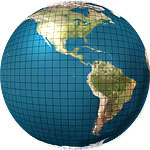
 does one represent the surface of a sphere on a flat surface? This question has occupied cartographers for centuries as they attempted to find effective ways to map the Earth. They found a solution, or rather, they found dozens of solutions, each involving a different compromise. Consequently, cartographers offer us a menu of choices.
But, 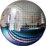
 what do maps of the Earth have to do with taking pictures? The trick is to realize that it is the same problem, only now we are at the centre of a spherical space, rather than outside it. The horizon replaces the equator; the zenith, the north pole; and the nadir the south pole. As long as we have all the data we can just build a map of the space as any cartographer would do. And as some of the pictures on this site devoted to Kootenay Lake show, photographers do delight in interesting mappings—well, this one certainly does.
Now, 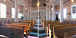 we face the problem of how the necessary data for the map cum image is assembled in the first place. It is a question of how one assembles an initial panorama which captures all possible directions: front, back, left, right, up, down, and everything in between. Many casual photographers have attempted a panorama by piecing together a series of shots they took, say, around the horizon during a vacation. It just doesn’t work very well: the pictures don’t fit at the edges. Alas, the problem lies in the rectilinear mapping used by conventional lenses: it is a projection of the spherical surface onto a tangent plane touching the sphere in the centre of the image. As the camera is pointed in different directions, the tangent plane changes with the result that the edges just don’t match.
The solution to stitching adjacent photographs is to choose a mapping which does not change from one shot to the next. In these days of computers, it doesn’t much matter what lens is chosen for taking the pictures, the resulting images are first transformed into a common mapping, they are then seamlessly joined. Finally, the cartographer’s art is followed and the stitched image can be transformed into an interesting mapping for display.
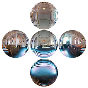
For this project, a fish-eye lens was used, and five shots were taken: three at 120° intervals around the horizontal, one looking straight up, and one looking straight down. This approach provides a great deal of overlap to enable a smooth stitching, and to remove evidence of both photographer and tripod. The fish-eye pictures will not, of course, be able to be stitched without first being transformed, but that step is straightforward.
The pictures 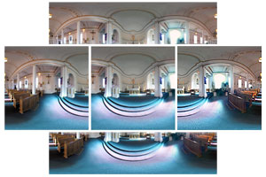 with a fish-eye projection were then transformed into ones with an equirectangular projection (a simple cartesian mapping of azimuth and elevation). It is clear that not only will the separate images now fit, but that there is extensive overlap to allow a smooth stitching.
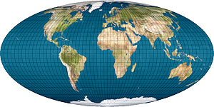
The separate equirectangular images are now joined to produce a single equirectangular image with a width of 360° and a height of 180°. The horizon lies along the middle, the zenith extends along the top, the nadir extends along the bottom, and the sides match. 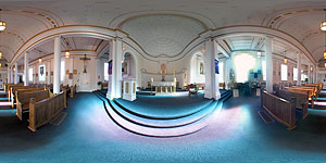 In short, the whole sphere has been mapped onto this plane, albeit with inevitable distortions. Nevertheless, in addition to this being an interesting representation in of itself, as it contains information on the whole sphere,
 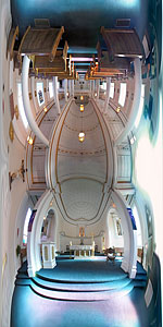 it serves as a base for all other transformations.
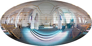
For example, a simple, but dramatic change would be to imagine wrapping the projection around the sphere in the vertical rather than the horizontal direction. This is accomplished by merely rotating the axis by 90°.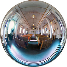
The flood gates are now open and the range of interesting mappings is extensive, and like the two equirectangular projections shown there, even images with the same map projection can look very different if the axis points in a different direction. Who can deny it, mathematics is just plain (chuckle—plane) fun!
Visual delights extend well beyond doing such things as viewing the nave as if the camera were replaced by a garden globe (right).
One can also use the data to create a navigable image: a seemingly conventional (rectilinear) image, but one which can be dragged to present any direction, including up and down. Try clicking and dragging in the seemingly normal image to the right.
Quite 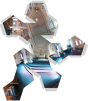 possibly, the piece-de-resistance in all of this is a version designed to be printed, cut out, folded and pasted to make a three-dimensional representation of the scene. The one on the left wraps the scene around a dodecahedron.
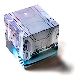
And, to the right, is a completed construction in the form of a cube.
As one can see, the presentation of a full-sphere image offers a visual feast: beautiful spaces combined with an arresting presentation. Not all of these variations are yet presented on this site, but, in time....