Toponymy
Toponymy — the study of place names.
Herein lies a toponymy of some of the places around Kootenay Lake. This page has relied heavily on the input of Greg Nesteroff.
Naming conventions Is it Johnson’s Landing, Johnsons Landing or Johnson Landing? Obviously, it originally was the first: the landing belonging to someone named Johnson. I must admit that adopting either the first form (the name is possessive), or the third form (the name becomes an adjective) makes good sense to me. But, alas modern Canadian toponymic practice chooses the second (illogically making the name a plural). This is really quite bizarre: just how many queens does it take to fill Queens Bay?
Ainsworth Hot Springs
After John and George Ainsworth, father–and–son capitalists from the U.S. who staked the townsite in 1883. Prior to this it was known as Hot Springs Camp. The post office opened in 1890 as Ainsworth and was re–named Ainsworth Hot Springs in 1964 to promote tourism.
Argenta
From the Latin noun for silver: argentum. Named by the Argenta Mining Co., but whether the company was named for Argenta Creek or the creek for the company is not known. First mentioned in a newspaper ad in 1892.
 Atbara, on the West Arm has a climate a great deal different from its namesake in Sudan.
Atbara
For the Sudanese city that Lord Kitchener captured at the same time as the Bedlington and Nelson Railway was under construction (Bedlington is now called Rykerts; it is the border crossing just south of Creston). There were two places along Kootenay Lake which used the name, Atbara; the first was near Sirdar. After this stop was eliminated, the name was assigned to the siding at Laska Creek, west of Harrop, in 1942.
Balfour
Balfour was pre–empted in 1889 as a townsite by Charles Wesley Busk. One source claims that it was named by Busk after Lord Balfour, the British statesmen and future prime minister, whose family had mining interests in the area. (However, muddying the question of just who was the eponym is the fact that there was a D.B. Balfour living there between 1892 and 95.) Busk named three streets after himself: Charles, Wesley, and Busk. Other streets took the names of his family members. An addition to Balfour in 1910 was known as Riverside, although this name did not last. When the ferry terminal moved to Balfour from Fraser’s Landing, the latter name also vanished from common use (although the name survived as Fraser Narrows), and the area became more or less part of Balfour.
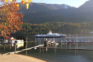 Balfour is the western terminus of the Main Lake ferry.
Blake
Railway siding that may have been named for Anglican missionary, W.G. Blake.
Blaylock Mansion
The mansion built in the English Tudor style in 1934-35 for Cominco executive Selwyn G. Blaylock is one of the largest and best-known homes in West Kootenay. Blaylock called it Lakewood, but it is now more commonly referred to by his own name. After his death in 1945, his widow lived here alone for over thirty
years. Subsequently, it changed hands several times, and is currently a bed-and-breakfast.
BOB
Big Orange Bridge—a whimsical name long applied to the bridge between Nelson and the North Shore (built in 1957). Curiously, the bridge wasn’t always orange, but started life as silver with green trim.
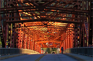 BOB: the Big Orange Bridge
Boswell
Governor General Earl Gray bought land here in 1906 during a tour of Kootenay Lake. The surveyor he hired was named Elias John Boswell (1870–1956).
Camp, cabin and cottage
From its earliest years on this lake, my family went to Camp in the summer. Now, the place offered reasonably comfortable accommodation, yet, the building was called a cabin, and the whole place was a camp. Such usage is characteristically western Canadian: a Torontonian would have visited the cottage; we went to camp. Around Kootenay Lake, the word, camp, is applied to all manner of summer retreats. These range from family dwellings to church properties (Camp Koolaree, Camp Lourdes), and even the more modern nature retreats (Tipi Camp). However, the upscale, year-round Yasodhara Ashram styles itself a study centre.
Cedar Point
A post office existed here from 1912-15.
Chahko Mika
Chinook Jargon meaning, “you come” thus, a meeting place. This name for the shopping mall along the Nelson waterfront was chosen through a contest. This was also the name of 1914 fair in Nelson which proved successful in every way but financial.
Central Kootenay
When the local governments, known as regional districts, were created in the mid–1960s, the Kootenays were divided amongst four of them: Kootenay Boundary, Central Kootenay, East Kootenay, and Columbia Shuswap. Prior to this, the term Central Kootenay did not exist, and with a few exceptions, the public has not adopted it for other purposes, for it seems to find little favour with residents who continue to think of themselves as living in the West Kootenay. The entire Regional District of Central Kootenay lies within West Kootenay.
Clothesline Point
Whimsically inspired by a Nelson family which frequented the spot—“it is where the Wragges hung out”. Clothesline point is on the North Shore about two kilometers from the orange bridge and before the road was straightened and paved about 1950, it was the location of the Kokanee Lodge. Now it serves as a popular public beach.
Clubb Landing
For Joseph P. Clubb, who filed a pre–emption in 1897. It became known as Clubb Landing in 1904, and had a post office in 1906–07.
Cody Caves
After Henry Cody, who was credited with discovering the caves while prospecting in the early 1890s. Cody also lent his name to a creek and townsite near Sandon.
Coffee Creek
According to G.P.V. and Helen Akrigg, an early mining operation on the creek created muddy water, hence the name. While some sources have suggested that the creek was named for George T. Coffee, a 1906 visitor, there are frequent references to Coffee Creek starting in 1888 and through the 1890s.
Columbia Basin
As a geographic region, it refers simply to the drainage area of the Columbia River. For the purposes of the Columbia Basin Trust, it is only the portion on the Canadian side of the border. Therefore the whole of the Kootenays are considered part of the Columbia Basin, but the Boundary is not, as its waterways empty into the Columbia in Washington State. Although the Columbia Basin has never been a social region, the Trust seems eager to promote it as one, referring to “Basin
residents” and of people “living in the Columbia Basin.” This usage has met with a rather limited success among the public which identifies more with the word, Kootenay, than, Columbia, and probably thinks of a basin more as a place to wash rather than to live.
Crawford Bay
For Jim Crawford (White Man Jim), a prospector and trapper. Authors Terry Turner and Susan Hulland say the inlet itself was identified by this name on maps of 1891–92, but the settlement appears on Perry’s Mining Map of 1893 as Cocklethorpe—presumably after William Cockle, the first pre–emptor. The name changed to Crawford Bay by 1901, and a post office opened three years later. A second post office, known as Port Crawford, opened in 1916. They amalgamated in 1954.
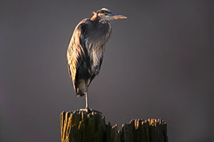 A Blue Heron stands atop the piling of an ancient landing along Crescent Bay.
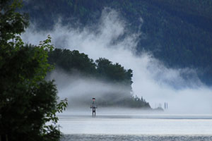
Crescent Bay
Also known as Nine Mile, and formerly known as Farrington’s Landing. The name changed before 1921.
Davie
A phantom townsite on the East Shore, promoted in 1894. Presumably named after then–B.C. premier Theodore Davie.
Deanshaven
For Richard T. Deane and family, who purchased the property in 1909. Variously spelled Deanes Haven and Deaneshaven, it didn’t appear in B.C. directories until the 1920s or on government maps until 1936. According to authors Susan Hulland and Terry Turner, Deane once threatened to sue the CPR when they distributed a timetable mistakenly identifying the stop as Dean’s Harem.
… Dolphin
Dolphins dot the Lake, but are found particularly in the shallows and off the sand points of the West Arm. Each has a name associated with its location: e.g., Kokanee Narrows Dolphin, Fraser Narrows Dolphin, Rhinoceros Point Dolphin.
Drewry
Railway station named after the mountain to the northwest, which in turn was named for writer and mining developer J.C. Drewry.
Elephant Mountain
The official name of the mountain directly north of Nelson is Nelson Mountain. But, the common local name reflects its appearance as seen from the City.
Fraser’s Landing
The Fraser name is applied to places on either side of the Main Lake. The community of Fraser (western side of Balfour), the Fraser Narrows, and the now vanished Fraser’s Landing were named after Sydney S. Fraser (1867–1947), who purchased 400 acres and settled there in the fall of 1906. Fraser Lake (between Kootenay Bay and Crawford Bay) was named after William (Bob) Fraser (a man who lived to over a hundred). Fraser’s Landing was in place and so named by 1909. In 1931 it was chosen as the western terminus of the Main Lake ferry. The landing was dynamited when the terminus moved to Balfour in 1947, but the name remains attached to the narrows (the narrowest of those on the West Arm), and to a lesser extent to what is essentially west Balfour. The landing was at the bottom of Heuston Road where the power line now crosses the narrows.
Front and back of a lakeside home
For a lakeside home, the front faces the water. As a naming convention this clearly differs from that used for most homes where the front faces the road or street. But, this is more than mere terminology: it also influences home design—the house is designed to face the water. Sometimes one sees a home along the shore where a conventional suburban plan was pressed into service; the result is usually incongruous. But, even when house plans take lakeside living into account (and most do), an amusing inconsistency arises. In the early years of lakeside living, home access was always from the water, but now visitors are far more likely to approach from the land. The result is that for a modern lakeside home, the front door is at the back of the house. It was not always so, the oldest homes along the shore clearly place their front doors on their fronts (lakeside).
Fry Creek
Named by 1897 for prospector and trapper Richard (Dick) Fry, who arrived at Kootenay Lake 30 years earlier during a short-lived gold rush to 49 Creek. Sometimes misspelled Frye Creek.
Gray Creek
Called Ironton on some early maps, while Perry’s Mining Map of 1893 shows it as Greys. Also known as Gray’s Creek and Grays Creek before and after the Gray Creek post office opened in 1908. The name may have been after an old prospector named Grey, supposedly related to novelist Zane Grey; or for one–half of the partnership of Redding and Gray, guiders and packers; or for John Hamilton Gray, a civil engineer and surveyor.
House signs As if the Canadian naming convention of (former) possessives isn’t odd enough, many house signs attest to a local practice which is stranger still. Say, a family’s name is McGregor. Their house sign is typically written: McGregor’s. Now, had it been written McGregors’, it would proclaim this the home of the McGregor family. But, writing it McGregor’s implies that this is the home of The McGregor—that is, herein dwells a hereditary lord.
Harlequin Island
The island east of Fraser Narrows and close by the south shore. The reason for the choice is unclear.
Harrop
After Ernest Harrop, who settled there in 1905. He was also the first postmaster when the office opened two years later. It closed in 1963. Formerly known by several other names, including 13–mile Point, Sawmill Point, McCoy’s Siding, and West’s Landing.
Johnsons Landing
After Algot Johnson, a Swedish miner who came to Kaslo about 1895. While waiting out a storm during a day’s fishing, he walked up Kootenay Joe Creek and discovered a flat that pleased him so much he started saving to buy a piece. The 1911 census shows him living at Johnsons Landing, although newspaper accounts called the spot Fry Creek. The post office operated from 1917–70.
Kaslo
After Kaslo (or Caslo) Creek, which was named by 1889, but its origin is a great geographical mystery. The most likely explanation is that it is a corruption of kala, the Ktunaxa term for black hawthorn. Postmaster J.W. Cockle transcribed it in 1905 as cassoloe, stating that it meant blackberry. A rival theory says Kaslo is derived from Johnny Kasleau (or Casleau), an early prospector who came up the lake looking for placer gold. However, there is scant evidence of his existence.
Kitto Landing
Apparently named for a W. Kitto. Kitto (or Kitto’s) Landing was named by March 1916, and probably quite a bit earlier.
Kokanee
The landing, creek, and park all take their name from the Sinixt word (not a Ktunaxa word, as this page previously claimed) for the land–locked salmon that spawn there. Thanks to the beer of the same name, it has become the most famous word indigenous to the Kootenays. The Kokanee post office operated 1902–15, with a brief closure in 1911.
Koolaree
Run by the United Church since its formation in 1931, Camp Koolaree is on the south shore of the West Arm opposite McDonald’s Landing. The name refers to the camp’s original purpose: Kooteeny Lake Religious Eduration. Pronunciation of the name is variable.
We think of Kootenay as a local name, but Greg Nesteroff points out that the proliferation of housing developments has caused the name to spread well beyond the Kootenays. See his article, Where the streets have our name.
Kootenay
The word Kootenay, or Kutenai, is almost certainly derived from ktunaxa, the aboriginals who lived mainly to the east and south of the Lake in the winter, but who fished, and hunted around the Lake in the summer. However, the name did not come from them directly; rather, it came from kutenáiua, the name which was given the ktunaxa by the a people living beyond the Rocky Mountains to their east: the Blackfoot. The name, ktunaxa is pronounced tuh-nah-ha-gh, where the final syllable has a gutteral sound made at the back of the throat.
Kootenay Bay
Appears on Perry’s Mining Map of 1893 as Lynchville, apparently named after its only resident, Mr. J. Lynch. Re–named Kootenay Bay in 1908 upon the opening of a post office, which closed in 1990.
Kootenay Crag
Rock climbers gave this name to the spectacular outcrop on the steep slopes of the south shore of the West Arm between Horlick’s Point and Five-mile Point. But, theirs seems to be a recent coinage. A number of us who lived on the North Shore opposite it have long known it as South-America Rock—it would not take more than a moment’s glance to know why.
Kootenay Lake
It is Kootenay Lake, not Lake Kootenay. Only the biggest lakes, such as Lake Superior and Lake Ontario, put the word, lake, first. As the ktunaxa (local aboriginals from which Kootenay is derived; see Kootenay, above) were also referred to as the Flatbow Indians, early references to the Lake sometimes called it the Flatbow Lake. David Thompson named it McGillivray’s Lake, after William and Duncan McGillivray, his superiors in the North West Company. However in 1844, Archibald McDonald of the Hudson’s Bay Company referred to it as Kootenais Lake, and with a change in spelling, this was the name which stuck.
Kootenay Rockies
Tourism B.C. has divided the province into several regions for marketing purposes, one of which comprises the Kootenays, and which they style the Kootenay Rockies. Prior to 2003, they called this region the Rockies, but West Kootenay residents would often point out that they did not live in the Rockies. The bureaucratic response of renaming it the Kootenay Rockies represents scant improvement in that all of their marketing region is in the Kootenays and very little of it in the Rockies. So, places ranging from Kimberley to Rossland are being sleazily promoted as being in the Rockies, when, in fact, they are not. Oddly, in the late 19th century, Kootenay may have been a better–known word than Rockies. Several products, including stoves, boots, and even a patent medicine traded on its good name.
Kuskanook
Supposedly derived from a Ktunaxa word meaning edge or end of the lake. The town by this name, formerly known as Kalama, flourished briefly in 1898. It was originally spelled Kuskonook, but when the CPR built a steamship by the same name, they changed it to Kuskanook, which became widely accepted. There is also a Kuskanax Creek (spelled Koos–Ka–Nax on some maps) near Nakusp, although this was traditionally Sinixt territory.
…Landing
[To do]
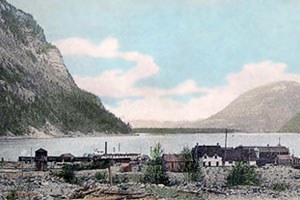 This c. 1910 postcard proclaims: “Lardo B.C.—North End of Kootenay Lake.” Today it looks much the same: the spelling has become Lardeau, the sternwheeler has vanished, and the homes are more modern, otherwise….
Lardeau
Like Kaslo, there are multiple theories behind this name, which first appeared on an 1865 map by James Turnbull. Also spelled Lardo and Lardeaux, it applied to the entire district between Kootenay Lake and Upper Arrow Lake. It may have come from 19th century slang for a rich or fat prospect, although there were also reports of a voyageur named John Lardeau. (Lardeau is a rare name in both Quebec and France; a loose translation of the name is a diminutive of bacon.) The Lardo townsite was surveyed in late 1892 and immediately ran into conflict with a rival town on Upper Arrow Lake named Lardeau. Both applied for post offices, but were refused unless one changed its name. Eventually Lardeau vanished from the map and a post office opened at Lardo in 1899. Inexplicably, however, the spelling was changed to Lardeau in 1947. The post office closed in 1967.
Longbeach
Formerly Hallett’s Landing and 13 Mile. In 1913, residents wishing a new name produced a shortlist of Connaught Bay, Cottonwood Point, and Longbeach. They let the CPR make the final decision.
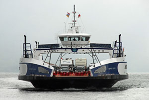 The MV Osprey is the main ferry boat used on what is billed as the longest free ferry in the world.
Longest Free Ferry Ride in the World
This is a billing, rather than a name. It was first applied to the Main Lake Ferry by the Nelson Board of Trade when the tolls came off in 1963. No evidence for this claim is offered, and even if true in the beginning, is it so now? Well, who knows? While the superlatives of tourism offer amazingly thin gruel, it remains that the ferry ride is long, free and beautiful.
Main Lake
The portion of Kootenay Lake which lies in the Purcell trench between the Purcell Mountains and the Selkirk Mountains. The term is used as a way of distinguishing it from the West Arm which lies entirely within the Selkirks. The Main Lake is deep and lies in a mainly north–south direction, while the West Arm is shallow and runs in a mainly east–west direction.
Marshmallow Bay
A local name for the bay with the little sandy beach on the east side of Troup is Marshmallow Bay. It was so named in the early 1970s by a small North Shore girl who was impressed by the tranquillity of the spot.
 McDonald’s Landing on the North Shore near Six Mile.
McDonald’ps Landing
For Duncan A. McDonald, who filed a pre–emption in 1894. Better known today as Six Mile, although there is still a sign designating McDonald’s Landing at the government wharf. In 2011, the landing was transferred from the (government department of) Fisheries and Oceans to the RDCK.
…Mile…
Many names on the West Arm contain the word, mile: Five-mile Creek, Seven-mile Point, Nine-mile Dolphin. The reference is a survival from the days of the sternwheelers and is an approximate distance along the water from the Nelson City Pier (at the foot of Hall Street). The names have stuck as a descriptor of locations—someone might say, “my cottage is at Four Mile”—despite the fact that distances are now more likely to be specified along the road from the orange bridge in kilometers. Occasionally, the earlier scheme produced odd results: the Six-mile Lakes are a lot farther than six miles from the pier, but they empty into Duhamel Creek, which was once called Six-mile Creek because its mouth is approximately six miles from the pier.
 A portion of this largest of all Kootenay Lake ships, the Nasookin is now a home located about four kilometers along the North Shore from the bridge.
Mirror Lake
The post office, which operated 1909–70, allegedly appeared in Ripley’s Believe it or Not! as the world’s smallest. It now sits next to the S.S. Moyie in Kaslo.
Molly Gibson
The landing and mine were named after another mine in Aspen, Colorado, which was in production in the early 1890s. The Molly Gibson post office operated 1911–15, except for a ten–month closure in 1911–12.
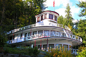
Nasookin
Not a place name per se, but a prominent landmark, being the remains of the largest Kootenay Lake sternwheeler, now converted into a home on the North Shore. Nasookin was supposedly the Ktunaxa word for supreme chief. Next to the ship, Nasookin Rd. leads to the Nasookin Heights subdivision.
 Nude Rock on the south shore opposite Crescent Bay is seen here without the nudes. It gained its informal name in the 1930s.
Nelson
Originally called Salisbury after the Marquess of Salisbury, Prime Minister of Great Britain, and Stanley, after Lord Stanley, Governor General of Canada. There was already a place in the Cariboo called Stanley, so in applying for a post office in 1888, the name was changed to Nelson, after Hugh Nelson, B.C.’s Lieutenant Governor.
Nude Rock
This denotes a rock outcrop on the south shore which gained its informal name in the 1930s when some girls from Crescent Bay would row across to swim and bath off the rock.
Outlet
This name, probably dating to the 1880s, describes the region where the waters of the Main Lake flow into the West Arm. It collectively refers to the communities of Balfour, Procter, Queens Bay, and maybe down the arm as far as Harrop.
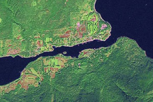 Outlet describes the portion of the Lake and the communities around it where the water flows from the Main Lake (upper right) into the West Arm. The constriction on the arm at centre left is the Fraser Narrows, and to its east is Harlequin Island.
Pilot Bay
Believed to be named for the boat captains, who were also known as pilots. Pilot Bay is the most protected harbour on the lake, and was a place to run for cover in bad weather. One source suggests the name was a corruption of “Pirate Bay” and gives a fanciful explanation. However, references to Pirate Bay appear to have been sarcastic aspersions on the Galena Trading Co., which had a store there. A post office operated 1892–98.
Procter
After entrepreneur Thomas G. Procter, who bought property that became known as Procter’s Landing. He platted a townsite in 1897 called Kootenay City, but by 1900 the name had reverted to Procter. It was frequently misspelled Proctor even while its eponym was still alive. The confusion may have been attributable to two CPR employees named Proctor, one a railway construction engineer who worked on the line that passed through the town. The CPR spelled it with an or in their timetables, maps, and railway station, although decades later they insisted the proper spelling was with an er. The post office opened in 1906.
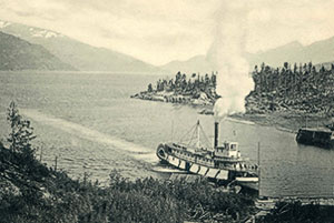 The Pilot Bay Landing with the S.S. Kokanee arriving. The Kokanee operated between 1896 and 1923.
Pulpit Rock
An outcrop of rock opposite Nelson that reminded the early settlers of a pulpit in an Anglican Church. It is the eye of Elephant Mountain.
Purcell Mountains
Akrigg tells us that these mountains were named by “Dr. James Hector after Goodwin Purcell (1817-76). Purcell, the last chieftain of the O’Leary line, was also Professor of Therapeutics and Medical Jurisprudence at Queens University, Cork. He had been on the selection committee which had chosen the personnel for the Palliser expedition with which Hector was serving.”
Queens Bay
According to historian, Ted Affleck, it was called this by 1883, but whether after Queen Victoria or another monarch is unknown. Post office operated 1909–64.
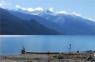 The Purcell Mountains as seen from Lardeau.
Riondel
For Count Edouard Riondel, president of the Canadian Metal Co., which acquired the Bluebell mine in 1905. S.S. Fowler, the company representative who applied for a post office two years later, selected the name. His first choice was Bluebell, but it was turned down for reasons unknown. He then considered Hendryx, as the camp was formerly known, but finally decided on Riondel. To answer a perpetually vexing question, Fowler wrote: “It is or should be pronounced Ree–on–del with accent very slightly on the first syllable.”
Roberts Bay
This bay in front of Blaylock’s was probably named for Mike Roberts, the wood carver for the mansion.
Sanca
Derived from san’ka or ksanka, one of two words the Ktunaxa people used to describe themselves as a whole. Used particularly in Montana, but also by the Lower Kootenay. Some anthropologists speculate ksanka applied to the Lower Kootenay band and ktunaxa to the Upper Kootenay band.
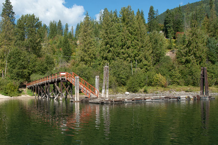
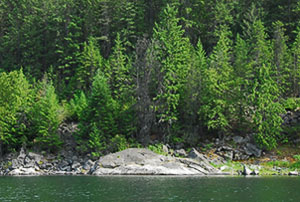
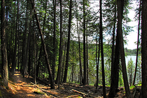 Sawmill Cove is one of the great destinations in Pilot Point Park, and indeed, on the whole Lake. While this is a view from the trail through the woods along its eastern shore, the cove is perhaps best visited by boat on a lazy summer’s day. Prepare for a languid swim in tepid waters followed by a picnic among the trees—idyllic!
Sawmill Cove
William Parsons Sayward and Joshua Davies had a sawmill here between 1890 and 1903. Sayward was a lumber baron who also had mills in other parts of BC. Sayward on Vancouver Island is named for him, as was a townsite at today’s Columbia Gardens. Sayward and Davies were also partners in the West Kootenay Land Company along with Thornton Fell, E. Crow Baker, and D.C. Corbin.
Selkirk Mountains
Akrigg tells us that “These were originally named Nelson’s Mountains by David Thompson, after the hero of Trafalgar (we now have the subordinate Nelson Range). After the union of the NorthWest Company and Hudson’s Bay Company in 1821, they were renamed in honour of Thomas Douglas, 5th Earl of Selkirk (1771–1820).” This is the same Selkirk who established the settlement in Manitoba.
…Shore
Kootenay Lake’s north and east shores are part of local nomenclature. The North Shore runs along the West Arm roughly from Johnston Rd., directly opposite Nelson, to Balfour. The East Shore is the area along the South Arm from Kootenay Bay to Kuskanook, a former sternwheeler terminus. Some East Shore residents refer to it tongue in cheek as the Best Shore. North Shore residents can be forgiven for a certain toponymic confusion. Consider the problem faced by those who live between the bridge and the park: the BC Government assures them they don’t live in Nelson; Canada Post says they do; and the telephone company claims they live in some never–never land called North Nelson. Sigh....
Shutty Bench
After John and Andrew Shutty, who arrived here from Czechoslovakia in the first decade of the 20th century. They originally spelled their surname Schuletty, and it appears this way on some early maps.
Sirdar
The rank assigned to Lord Kitchener when he was commander–in–chief of the Egyptian army. Apparently derived from an Urdu word. Oddly, Creston was briefly renamed Sirdar in 1898–99. Sirdar was then assigned to the place presently known by that name. The post office opened in 1900.
Sitkum Creek
Chinook jargon for middle or half—an appropriate name given that the creek lies roughly half way along the West Arm. Chinook jargon is eighteenth and nineteenth century trade language of western North America.
Sunshine Bay
Called Mallow by the CPR, although the origin of that name is unknown.
Troup Junction
For Captain James W. Troup, superintendent of the Columbia and Kootenay Steam Navigation Co., and later manager of the CPR’s B.C. Coast Service. The name was changed from Five Mile Point sometime before 1905. The name is frequently misspelled as Troupe.
Tye
After William Francis Tye, the CPR’s construction engineer on the Columbia and Western Railway, and chief CPR engineer 1904–06.
Walker’s Landing
For Fred Walker, who bought 90 acres here in 1910. According to historians Terry Turner and Susan Hulland, it was originally part of the 650–acre Yasodhara property owned by the Langford Lang Co. Called Walker’s Landing on the CPR schedule.
West Arm
Kootenay Lake has three arms: North, South, and West. The North and South arms constitute the Main Lake. The West Arm is shallower than the other two and extends westward for about thirty kilometers from about half way up the Main Lake.
West and East Kootenay
The Kootenay district was first split, for the purposes of mining administration, into North and South Kootenay. In 1888, it was more aptly reorganized as West and
East Kootenay, with the Purcell mountains as the dividing line (and not Kootenay Lake, as some travel writers would have it). By 1897, this led to the plural form Kootenays, which is now commonly used to mean any part of the district. North and South Kootenay survive but not in their original contexts: South Kootenay refers to the Trail area while North Kootenay is sometimes used to describe the region between Nakusp and Kaslo.
Willow Point
C.W. West, who moved here in 1901, named it after the willows growing on the sand bar. A post office operated 1905–15.
Woodbury
The creek and village are after brothers Arthur K. and Charles J. Woodbury, both of whom may have explored the area in the early 1880s. Arthur was editor and proprietor of the Spokane Chronicle, while Charles staked the Lulu claim. Often spelled Woodberry.
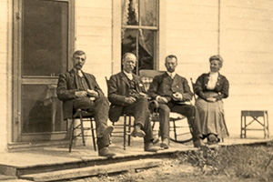 Rob Fraser Lanford (second from left), the man who named Yasodhara, plays host to his cousins in May 1909: Sydney S. Fraser (left, of Fraser’s Landing), the Rev. Thurlow Fraser (of Owen Sound, Ontario) and Isabella Fraser (Sydney’s wife).
Wynndel
No satisfactory explanation for the origin of this name exists, although some sources say it was after an early fruit grower named Wynndel. There was also a Chester L. Wynn, editor and manager of the Creston Review and a Mr. Winn who bought fruit land in nearby Erickson. The name was not commonly used before the post office opened in 1910, and its spelling was fluid, appearing as Wynndell, Wyndell, and Wyndel. Formerly known as Duck Creek.
Yasodhara
Predates the ashram of the same name. Apparently named in the early part of the 20th century by R.F. Langford of Kootenay Bay, proprietor of the Langford Land Co. Yasodhara (pronounced Yash–sho–dra) was the Hindu god Krishna’s mother and also the wife of Prince Siddhartha, who became Buddha. The name was a prime factor in Swami Sivananada Radha’s decision to buy the property in 1963 and establish Yasodhara Ashram.
![]()