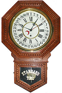
 Time This wall clock was a common feature of early shops in the area as wholesalers gave them away during a promotion.
A Chronology of the Lake
Herein lies a chronology of some events of interest around Kootenay Lake. For more information on some of these topics read D.M. Wilson’s very informative articles on the West Arm, East Shore, and Don Gayton’s Cautionary Tale on the subject of the phosphates, shrimp, and the fish.
Here is the contact to make suggestions for this chronology.
An image mouseover displays a caption; a menu mouseover (upper left) displays other topics.
2008
In April, The Nature Conservancy of Canada purchased Darkwoods, a 550 km2 property in the south Selkirk Mountains on the west side of the South Arm. Duke Wurttemberg of Germany had acquired it in 1967 as a potential refuge against Soviet expansion, but other than some modest logging it has remained unoccupied by other than Mountain Caribou, Grizzly and old–growth trees. The stewardship of the NCC is welcomed.
2004
On January 11th, the MV Anscomb took only about three minutes to sink in 40 metres of water at Woodbury. A year earlier it had been sold to Clayton and Glen Jones who hoped to use it as a floating restaurant. After a conflict over mooring it in Kaslo Bay, it was moved to Woodbury where a cold snap caused pipes to break which alowed lake water to enter the boat.
2001
Around this time the wooden pilings on dolphins began to be replaced with steel pilings. The transition took a number of years.
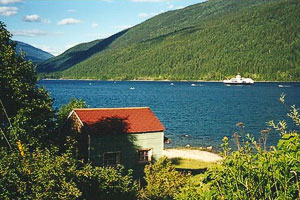 After being launched at Nelson on July 1, 2000, the MV Osprey 2000 travels up the West Arm (as seen from Shannon Creek) to become the Main Lake ferry. Note the accompanying flotilla of small craft.
  Ron Welwood
2000
The MV Osprey 2000 was launched at Nelson on July 1st, and entered service as the new Main Lake ferry running between Balfour and Kootenay Bay on August 26th. It replaced the MV Anscomb which served for over fifty years. The MV Balfour (1954) supplements the Osprey during the busy summer season.
1995
On July 6th, the Columbia Basin Trust was created to benefit the region most adversely affected by the Columbia River Treaty (1964).
1995
The Fish and Wildlife Compensation Program was created to consolidate all previous compensation programs in the Columbia Basin. The Program began delivering projects to sustain and enhance fish and wildlife populations affected by hydro dams. The FWCP now manages the fertilization project.
1993
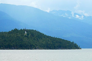
Pilot Bay Lighthouse was taken out of service on June 30th after 89 years of service. Then in 1995 it was transferred to the BC Government where it became part of the Pilot Bay Provincial Park.
1992
BC Environment and BC Hydro began a five–year experimental fertilization project in North Arm of Kootenay Lake. The incentive for this was the steady decline in the number of spawning kokanee in the Lake (particularly the North Arm). The problem has been traced to declining nutrient levels resulting from sediment settling in the still waters behind dams. As those nutrients were no longer transported into the Lake, an experimental programme was launched to compensate for it by fertilizing the water.
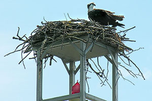 Since the 1970s, no well equipped dolphin is without its osprey platform.
1989
The railway line which passed through Nelson’s Mountain Station and clung to the steep side of the mountain along the south shore as it descended to Troup ceases operation. It started as the Nelson and Fort Sheppard Railway (1893), became the Great Northern Railway (1898), later known as the Burlington Northern. Ultimately, the rail bed became a recreational trail.
1983
Canada adopted the aids to navigation system used internationally. Thus began the transition of the dolphins on the Lake from having a series of wooden slats pointing to the channel to one of coloured squares and triangles. The older system was far more intuitive but only worked on a fixed structure such a dolphin; it wouldn’t work on an erratically oriented buoy.
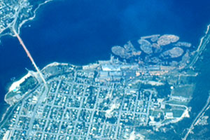 This July 1973 aerial view of the Fairview section of Nelson shows clusters of log booms adjacent to the KFP mill. Tugs had towed them from the upper end of the North Arm. The ninety–year–old era of log booms on the Lake ended in 1982.
1982
The era of log booms on the Lake came to an end with the closing of the KFP (Kootenay Forest Products) sawmill on the Nelson waterfront. Log booms towed downstream by tugs—often stored along the south shore between Horlick’s and Five–mile Point and to the east of Seven–mile Point—had been a staple of the Lake undoubtedly since the beginning of the lumber industry in the early 1890s. Inevitably some logs escaped the booms and became a hazard to boats. However, cottagers would (surreptitious) incorporate them into floats and cut them up for firewood. Even today there are remnants in the form of many deadheads found in places where booms used to be stored.
1975
Completion of the Libby Dam on the Kootenai River in Montana. This provides control over about 80% of the water flowing into Kootenay Lake. It also affected both local fish and wildlife habitat. Nutrient retention in Kootenay Lake (phosphorus loading) declined to one–third of historical levels following pollution control measures at Cominco’s fertilizer plant.
1973
The Cominco fertilizer plant (1953) at Kimberley shuts down and the phosphate levels in the Lake begin to fall. Indeed, they soon fall to below historical values in that now nutrients are being trapped in sediment behind the dams. This precipitates a decline in fish stocks.
1970s
Sometime in the early 1970s, platforms were added above the lights on dolphins. These provided a place for ospreys to nest. Prior to that time, when an osprey would build a nest on a dolphin (and so obscure the navigational light), a government agent would remove it.
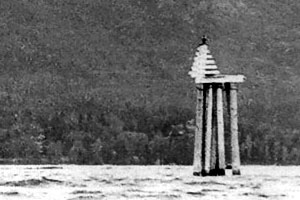 Prior to Canada’s 1983 adoption of the international navigation system, dolphins on the Lake pointed to the channel with series of wooden boards. This is the Five–mile dolphin in 1952; the platform for an osprey nest would not be added for another twenty years. Denis Daly
1967
Duncan Dam was competed on the Duncan River. Although this provided control over only about 10% of the water flowing into Kootenay Lake, it represented the major inflow for the North Arm.
1964
The Columbia River Treaty was ratified and implemented on September 16th. This was the framework under which upstream dams were built which tamed the worst of the spring floods: Duncan Dam on the Duncan River north of the Lake (1967), Libby Dam on the Kootenai River south of the Lake (1975).
1964
Passenger service was discontinued on the CPR railway line along the Lake and into Nelson.
1958
Cominco (CM&S) built a high-voltage power line along the North Shore mountainside, across the Main Lake, and over the Purcells to the Sullivan Mine at Kimberley. The span over the Main Lake was 3248 metres in length and at a minimum height of 37 metres above the water. On March 6th, 1962, Doukhobor dissidents used explosives to destroy the eastern pylon for the span, but it was soon rebuilt as a smaller structure.
1958
Passenger service along the lakeshore and through Nelson was switched from being a passenger car on a regular train to being a Budd car (apparently called the Galloping Goose), however the latter only last for six years.
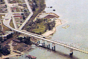 Nelson’s bridge started life painted silver with green trim. This aerial shot from a 1961 postcard shows the toll booth on the Nelson side. Tolls stayed in place until 1963.
1957
The bridge between Nelson and the North Shore was opened on November 7th. The ferry which linked the two shores since 1913 was retired. The bridge, along with the subsequent upstream dams, which were built as a result of the Columbia River Treaty (1964), transformed North Shore living. Prior to these events, perhaps only ten percent of homes were permanent residents, while the rest were summer cottages. A few decades later, the ratio had reversed. The bridge provided easy access to the North Shore and the dams, by limiting the worst spring flooding, allowed the use of more shorefront.
1957
The SS Moyie retired to Kaslo on April 27th after nearly sixty years of service.
1950s
Sometime around the mid 1950s, the road between Kaslo and Lardeau was completed (does anyone know when?). This road contributed to the demise of the Moyie in 1957.
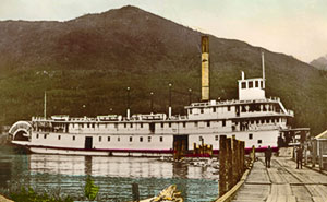
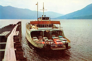 The MV Anscomb pulls into Kootenay Bay sometime in the 1960s.
1955
Kokanee Creek Provincial Park was established.
1954
The MV Balfour was launched to supplement the MV Anscomb as a ferry on the Main Lake.
1953
A Cominco phosphate fertilizer (a spinoff of the Sullivan Mine) at Kimberley starts dumping phosphate-laced wastewater into the Saint Mary's River, from where it flowed into the Kootenay River and thence into Kootenay Lake. Phosphate production reached a peak in 1967 and the decline in the clarity and purity of, and the increase in biota in, the waters of Kootenay Lake was evident to even the casual observer. The fertilizer plant closed in 1973 and water quality began improving thus ending the twenty–year era of murky waters.
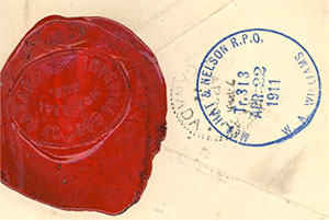 The trains and sternwheelers along the Lake carried not only passengers and freight, but also post offices. The cancellation on this letter reads: MED HAT & NELSON R.P.O (railway post office), Tr. 313, APR. 22, 1911, W.A. Williams (mail clerk). The letter was registered and so bore a wax seal (from the Imperial Bank of Canada).
1949
Mysid shrimp were introduced in Kootenay Lake as a food source for intermediate-sized rainbow trout. This tinkering with the Lake proved counter productive.
1948
A major spring flood on the Lake and throughout the Columbia Basin prompted the formation of an international commission to study the possibility of flood control in the basin. This lead ultimately to the Columbia River Treaty (1964).
1946
The SS Anscomb was launched by the BC Ministry of Transport as the ferry across the Main Lake running between Balfour and Kootenay Bay. It replaced the SS Nasookin as the Main Lake ferry. It had a capacity of forty vehicles, was 59.6 m. long, 14.1 m. wide, 570,000 kg (628 tons) gross weight , and 716 h.p. Although there had been a road between Kootenay Bay and Creston since 1931, its paving wasn’t completed until 1949.
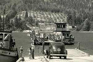
 Between 1931 and 1946, the SS Nasookum served as the Main Lake ferry running between Fraser’s Landing (seen here) and Gray’s Creek.
1946
The Geodetic Survey of Canada completed a two–year mapping of the depths of the Lake. This work served as the basis of bathymetric charts used to this day.
1933
Lewis Gilbert’s speedboat, the Ladybird, set a record of 68 miles per hour (109.5 kilometers per hour). The Ladybird was commissioned from Walton’s Boatworks in Nelson and was powered by a Liberty Airplane Engine from WW I, with a Garwood conversion. The Ladybird won the Championship of Kootenay Lake many times during her long career.
1932
More or less single handedly Selwyn Blaylock (best known locally for having built the Blaylock Mansion) destroyed what had been a thriving cherry industry around the Lake. About this time he clandestinely imported in a Japanese Flowering Cherry for his estate gardens, despite knowing it to be banned owing to disease. By 1933 a virus from his plants had spread to neighbouring orchards, and by 1949 it had ruined orchards throughout the Kootenays and across the border. However, the source of the infection was not determined until after Blaylock’s death in 1945. For the story of this unfortunate event, read Ron Welwood’s article, Big Little Cherry.
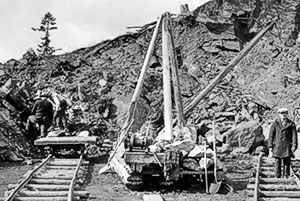 Early road construction along the lakeside was an arduous process. This picture, taken in March 1935, shows crews rerouting the road past the Longbeach bluffs from the east side. The gin pole (crane) was used to shift boulders onto the little flatcars thence to be rolled away on the makeshift tracks. Thurlow Fraser.
1931
The SS Nasookin was modified (a deck was removed) for use as a ferry across the Main Lake. It ran between Fraser’s Landing and Gray’s Creek. At the same time, a gravel road was completed along the East Shore of the South Arm from Gray’s Creek to Kuskanook.
1931
The CPR opened its railway line along the west shore of the Main Lake from Procter to Kootenay Landing on January 1st. The completion of the rail link from the end of the South Arm to Nelson brings an end to the era of big sternwheelers and big tugs on the Lake. A few sternwheelers live on for a while—the Nasookin is reduced in size and used as the Main Lake ferry until 1947; the Moyie services the North Arm until a road reaches the Lardeau in 1957—but the big vessel era is over.
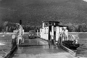 The first version of the Harrop Cable Ferry had room for four (small) cars. From the look of this car, the picture might have been taken in the 1940s. The ferry is on the Harrop side of the narrows.
1926
The (dirt) road was finished from Balfour to Kaslo (now Highway 31). The link between Ainsworth and Kaslo was completed in 1920, but the difficult stretch past the Coffee Creek bluffs meant that the link from Balfour to Ainsworth wasn’t completed until July 28th, 1926.
1925
On Aug 22nd, a four-car wooden cable scow started offering service between the North Shore and Harrop. There is still a cable ferry there providing road access to Harrop and Procter.
1913
A cable ferry between Nelson and the North Shore was started. It linked to the recently completed wagon road along the shore to Balfour. A cable ferry continued in use at the spot until the crossing was replaced by the bridge in 1957. The road underwent various upgrades particularly in the 1930s and early 1950s.
 This 1943 view of the Nelson Cable Ferry looks toward the North Shore.
1913
On May 1st, the sternwheeler, the SS Nasookin was launched at Nelson. While this was far from the only sternwheeler on the Lake, it was the largest—at 1,695,530 kilograms (1869 tons), the Nasookin even out weighted the Osprey 2000 at 1,615,000 kilograms (1780 tons)—further, from 1931 until 1947 it served as the Main Lake Ferry (having been modified for the job by the removal of one deck). Portions of this magnificent ship are with us still: the wheel house and upper deck are now a private home on the North Shore.
1909
The Hosmer, the largest and last of the big steam tugs on Kootenay Lake was launched by the CPR to provide barge service between Procter and Kootenay Landing. It was retired when those locations were connected by rail in 1931. The boiler and hull of the Hosmer’s wreck is still visible in the shallows between Bealby’s and Horlick’s Points just northeast of Nelson. Other CPR steam tugs were the Ymir launched in 1899, the Procter in 1900, and the Valhalla in 1901.
 Sitting near the crest of the point, Pilot Point Lighthouse has a commanding view of the three arms of the Lake. It guided sternwheelers and railway barges for decades.
1904
Pilot Bay Lighthouse was lit on June 13th and continued to shine for 89 years. Located on Pilot Point, it is roughly at the intersection of the three arms of the Lake and so can be seen well from any approach.
1900
On December 6th, the CPR opened the a railway line along the south shore of the West Arm from Troup to Procter. Among other things, this bypassed the (then) problem of the West Arm freezing over during the winter. See D.M. Wilson’s discussion at crowsnest.bc.ca.
1898
The era of big sternwheelers and big tugs begins on the Lake when the end of the steel moves to Kootenay Landing: the BC Southern Railway completes its line from Crow’s Nest. The era lasts until 1931 when the line is finally completed along the shore of the Lake eliminating the need for the passenger and freight cars to travel by water from Kootenay Landing to Nelson.
1898
The SS Moyie was launched. Although not the only sternwheeler to ply the waters of Kootenay Lake, it served the longest time—nearly sixty years— and is now preserved and beautifully restored in Kaslo.
1898
The Lake’s greatest shipping disaster took place in a storm in the evening of November 18th, when the sternwheeler, City of Ainsworth, went down at the entrance to Crawford Bay. Three passengers and six crew members perished. It wasn’t until 1990 that divers discovered the location of the wreck in 110 metres of water. Of course, the sinking of the Anscomb (2004) involved a much larger vessel (Anscomb: 570,000 kg; Ainsworth: 130,000 kg), but the Anscomb was not in service at the time, and there was no loss of life.
1897
Nelson was incorporated as a city.
1894
The June flood of this year was greatest known on Kootenay Lake. While the big floods of other years are all remembered, they pale by comparison to the Great Flood of 1894. “Continued warm weather and the large amount of snow in the mountains have caused the outlet at Nelson to rise fully thirty feet above low-water mark.” (Nelson Miner, June 9, 1894). One measure of the amount of water involved is found by looking at the stream flow on the Columbia River (at The Dalles, Oregon): nothing exceeded the 1894 flow, which was twenty percent greater than that of 1948, and over fifty percent greater than that of 1961.
1893
Kaslo was incorporated as a city.
1884
The S.S. Midge, the Lake’s first steam-powered boat was launched by William Adolf Baillie-Grohman (1851-1921).
1883
This was the summer of the great forest fire. Surveyors Farwell and Sproat traveled up the Main Lake in August and found that "the whole country appeared to be on fire, and the smoke [was] so dense it was scarcely possible to see anything at a distance of 200 yards." And in a view down the West Arm: "the timber has been nearly all burnt off." In subsequent years, settlers blamed the barren mountainsides on purposeful clearing by miners, but the conflagration was probably the result of lightning.
1882
The Bluebell mine was staked by Robert Sproule, the first claim on the shores of the Lake at what is now Riondel. On October 29th, 1886, Sproule was hanged for the (June 1th) murder of Thomas Hammill during a dispute over the ownership of the Bluebell.
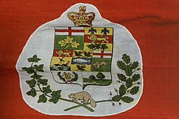 When BC entered Confederation, the badge on the Canadian Red Ensign was altered to reflect the addition of the new province. BC did not have arms at the time, so it was represented by the royal crest and wreath—seen in the lower left portion of the shield. Many such flags were to be flown around the Lake on sternwheelers and buildings right through WW I.
1871
British Columbia joined the confederation of Canadian provinces. There were only 12,000 European residents in the Province at that time and none of them live around Kootenay Lake.
1858
The Colony of British Columbia was created as a way to establish government and maintain law and order in the gold fields of the lower Fraser. Consequently, the (distant) Kootenays come under the colonial government then based in New Westminster.
1846
The International Boundary Treaty was signed, marking the 49th parallel as the dividing line between British territory and the United States of America. Thus, Kootenay Lake lies entirely within BC, although the Kootenay River passes through Montana and Idaho (where it is now styled the Kootenai River).
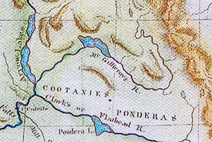 This 1838 map by Samuel Parker (based upon Thompson’s work) shows McGillivray’s Lake (on the river) about halfway between the Arrow Lakes and the Rocky Mountains. Note the label, Cootanies, below that.
1844
Why not call it Kootenay Lake? In this year, Archibald McDonald (1790-1853), the Hudson’s Bay Company Factor at Fort Colville visited the Lake and natives showed him the galena deposit (staked in 1882 as the Bluebell mine). He referred to the body of water as “Kootanais Lake.” McDonald passed his ore samples on to John McLoughlin, the factor at Fort Vancouver, who noted that the region was too inaccessible to allow profitable mining. Factor McLoughlin’s correspondence used two older terms: the Lake is Flatbow, and the river is McGillivray’s. Yet, McDonald’s reference seems to be the earliest suggestion of the present name.
1808
On May 14th, David Thompson came within sight of Kootenay Lake when he paddled north on the river past (present–day) Creston. For four hours he paddled through the waters south of Kootenay Lake (Leach Lake, Duck Lake and Six-Mile Slough) looking for the Lake Indians. At eleven o’clock in the morning they found some who told Thompson that there was a second camp of their people about halfway up the Lake (present–day Balfour) at a point where the water flowed west to another great river (the Columbia). In keeping with the tenor of the times, and notwithstanding the fact that the Lake was already known to others and that he did not even visit it, he gave it a name: McGillivray’s Lake (after two brothers who likewise failed to visit it). For information on Thompson’s travels in this region see Walter Volovsek’s article, Star–gazer.
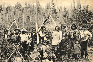 Archaeological evidence and historical writings record the extensive presence of the both the Ktunaxa and Sinixt around Kootenay Lake. Yet, generally they only visited in the summer for fishing and berry picking; they retreated south for the winter. This early local postcard was entitled, Nelson Indians.
1770
The first of several epidemics dramatically reduces aboriginal populations in the West Kootenay through the arrival of small pox passed through inter-tribal trade. At this time the Ktunaxa (pronounced, tuh-nah-ha-gh) were known by other tribes and Europeans variously as the Kootenais (many spellings), the Flatbow Indians, and the Lake Indians. The first two of these names were also applied to the River and the Lake with variations of the first finally prevailing.
![]()