Sun charts
Quick numbers The Earth’s axis is tipped about 23.5° to the normal to the ecliptic. The latitude of Nelson, Canada is about 49.5°.
Day length in hours =
(2/15) arccos[–tan(latitude) tan(declination)]
At solar noon on the summer solstice (June 21st), solar elevation is 90° – 49.5° + 23.5° = 64°.
Day length = (2/15) arccos[–tan(49.5) tan(23.5)] = 16hr 5min.
At solar noon on the winter solstice (Dec. 21st), solar elevation is 90° – 49.5° – 23.5° = 17°. Day length = (2/15) arccos[–tan(49.5) tan(–23.5)] = 7hr 55min.
At solar noon on either equinox (Mar. 21st, Sep. 21st), solar elevation is 90° – 49.5° = 40.5°. Day length = (2/15) arccos(–tan(49.5) tan(0)) = 12hr.
The track the Sun takes across the local sky varies from day to day and season to season. In the winter the Sun rises in the southeast, is low in the southern sky at noon, and sets in the southwest. In the summer the Sun rises in the northeast, is high in the southern sky at noon, and sets in the northwest. The paths the Sun takes across the sky on various days of the year can be presented as a family of curves. At the bottom of this document, two such Sun Charts for Nelson are presented: one for each half of the year. These diagrams were generated by the University of Oregon and are used here with permission (see below).
I have redrawn the separate charts as a single approximate one representing the whole year, and then superimposed the result upon various local panoramas. Although hardly precise, these images are suggestive of the sunlight that is available for the spot where the panorama was taken. Thus, at noon on the winter solstice, the Sun climbs to only about 17° above the horizontal, and as some places around the Lake have mountains to the south which have a higher angular elevation than that, they may spend days, or months, without direct sunlight. Even for somewhat lower mountains, direct sunlight might be lost for much of a winter day. At noon on the summer solstice, the Sun reaches about 64° above the horizon. The difference between the two noon solstice elevations, 47°, is equal to twice the tip of Earth’s axis. More panoramas will be added anon.
Panoramas The solar paths in these 360° panoramas are approximations based upon the Sun Charts at the bottom of the document; hour lines are compromises (from the anelema) and may be off by as much as a quarter hour. Times are Pacific Standard (add an hour for Pacific Daylight or Mountain Standard). The top (blue) path is June 21st; bottom is Dec. 21st; others are one month apart, so the second down is both May 21st and July 21st. Although approximate, these composite images are instructive.
See the raw Sun Charts, below the panoramas. Although calculated for Nelson, they are suitable anywhere around Kootenay Lake.
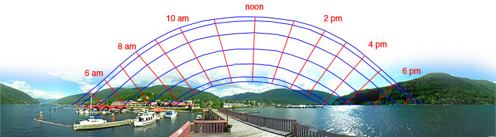 Public wharf, Nelson At Nelson’s waterfront, the mountains block an hour or two’s sunlight each morning and evening. This represents a larger fraction of the day in the winter than in the summer.
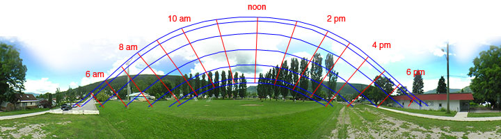 Lion Park, Nelson In uptown, the mountains loom larger to the south than they did in the lower town. On a winter day, there may be little more than a couple of hours of direct sunlight. The greater snow depth in this part of the town probably has more to do with the lesser sunlight than the greater altitude.
The Sun Charts, which follow, are © University of Oregon, Solar Radiation Monitoring Laboratory, and are used here with permission. These charts are the basis of the lines superimposed upon the panoramas, above. The Laboratory graciously allows the public to use its program on the Web to create Sun Charts for anywhere on Earth.
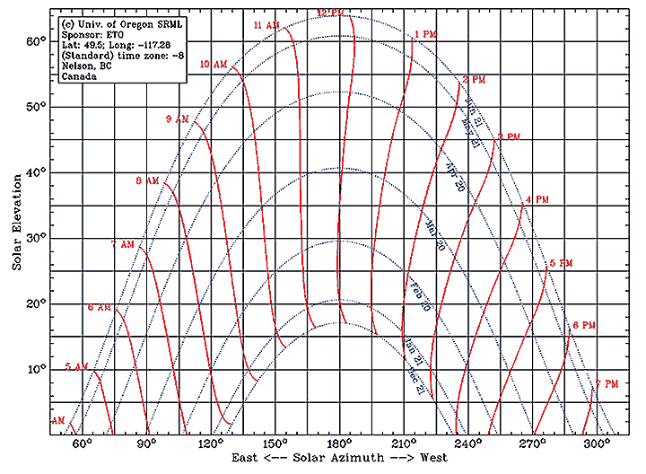 A Sun chart showing the path of the Sun across the sky at Nelson, BC, Canada, for the first half of the year. Due south corresponds to 180°. Times are in Pacific Standard Time; for Daylight Savings Time or Mountain Standard Time, add one hour.
© University of Oregon, used with permission
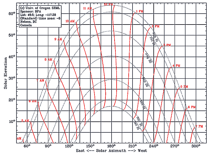 A Sun chart showing the path of the Sun across the sky at Nelson, BC, Canada, for the second half of the year. Due south corresponds to 180°. Times are in Pacific Standard Time; for Daylight Savings Time or Mountain Standard Time, add one hour.
© University of Oregon, used with permission.
![]()