Interior Wet Belt
One of the curious features of weather in British Columbia is the substantial amount of precipitation which falls in the West and East Kootenays.
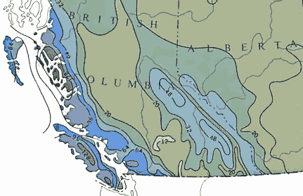 Annual precipitation (inches of water)
Along the coastal mountains a typical annual precipitation is 60 to 90 inches.
In the interior wet belt, the value is about half that. Yet, between these two regions the annual precipitation is under 20 inches.
from the Atlas of Canada, 1974
This is despite two facts: the region is far from the Pacific coast; adjacent areas, even to the west, are relatively dry. The considerable rain and snowfall in the Kootenays have profound implications that range from the aesthetics of the heavily forested mountains and valleys, to the diverse flora and fauna, to the disparate industries of tourism, forestry, and hydroelectricity, and finally to the very presence of Kootenay Lake itself.
Clearly, such an unexpected and important characteristic as, what is known as, the interior wet belt deserves to be explained if one is
to understand Kootenay Lake.
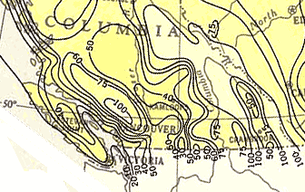 Annual snowfall (inches of snow)
In snowfall, the interior wet belt outdoes the coastal mountains, having a much more extensive region which gets over 100 inches a year.
Srikingly, the region in between gets less than half that amount.
from the Atlas of Canada, 1957'
However, the presentation of an explanation here is not without its problems: First, popular explanations are fraught with difficulties ranging from that of nonsensical physics (gulp!), to that of physically correct, but irrelevant, meteorology (bad, but not quite as bad as nonsense). Second, the correct explanation involves subtleties sufficient to stress any expositor.
When I set out to understand the issue, I was immediately aware of the first problem: the bankruptcy of the glib explanations. But, the mechanisms which make the Kootenays so moist were unclear to me. For help in piecing together the story, I sought counsel from two experts: Stan Stobbe, a meteorologist formally with Environment Canada’s Pacific Weather Central; and Dr. Roland Stull, a meteorologist, professor, and weather modeler at the University of British Columbia. With their help, the story emerged.
Popular (deeply flawed) explanation:
The moist low-level air over the Pacific first encounters the coastal mountains where the wind forces it up the mountain sides and over the top. As the air is lifted, its temperature drops, and because cold air cannot hold as much water (vapour) as warm air, water comes out in the form of clouds and precipitation. The air then flows down the back side of the coastal mountains and in descending warms and dries to make the Okanagan and Boundary region fairly dry. When it reaches the mountains of the Kootenays (Monashees, Selkirks, Purcells), the air is again forced up and once again produces precipitation.
This all seems to make perfectly good sense if your exposure to meteorology is limited to an earth science course in secondary school. However, on only modestly closer examination it has at least three problems.
Insight into two of the problems can be obtained by examining a cross section of the elevation through southern British Columbia.
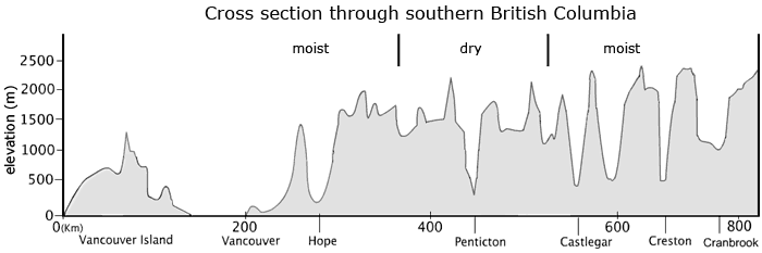 Cross section through southern BC
(heights exaggerated for clarity)
The moist and dry regions are labeled, yet, there is little in the mountains, as we see them here, which would make it readily apparent why the various regions are where they are.
First problem: Although the moist and dry regions are labeled above the cross section, there is nothing (at least to my eye) which would make it obvious why they are positioned where they are. Indeed, from the Coast Mountains through to the Rockies, the variation of the terrain hardly supports the explanation that the air flows down the lee side of the Coast Range to dry the lower Okanagan, and then flows up over the much higher ranges of the Kootenays. It looks all of a piece: mountains and valleys all with approximately the same relief. Clearly, something is wrong with the standard explanation.
 The Kootenays: mountains, water, forests.
But, why?
Second problem: This problem is subtler and depends upon a knowledge of the structure of the storms that bring moisture to the Province from the Pacific. Suffice to say, that (on the whole) the low-level air does not flow up and over the coastal mountains; rather, the low-level air is blocked by the mountains. Now, air does flow over the mountains, but most of that air was already near or above the elevation of the mountain tops, so it is not immediately obvious why merely passing over the mountains should cause it to ascend further (and so produce clouds).
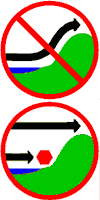 Traffic signs
Low-level air is not lifted over the coastal mountains.
Low-level air is blocked by the mountains. Air higher up flows across the mountains.
Third problem: Unlike the other two problems, the difficulty this time is not with what happens, but with the explanation of what happens. The issue is why the clouds form when air ascends. It is correct to note that when air rises, it cools and, if the air is moist, a cloud will form. So far, so good. The problem is with the explanation that we all learned in school which claims that this happens because cold air cannot hold as much water vapour as warm air. Curiously, it has been known for two centuries that air does not have a holding power for water vapour (let alone a temperature dependent one). And what matters is not that the air cools, but that the water vapour cools. A separate page treats this issue of condensation.
So, here is how things stand: ascent gives precipitation (albeit not for the reasons generally given), but it is not the least bit clear why there are the systematic patterns of rising and descending air over the southern part of the Province which, in turn, lead to the observed precipitation pattern. It is the burden of this section to account for this.
Assembling a solution
Speed of the winds: Curiously, we cannot solve the problem without some knowledge as to why the winds blow at the speeds they do. Wind speed is typically determined by a balance of forces. For winds well above the Earth’s surface the wind speed is determined by a balance between the pressure gradient force and the Coriolis force. Near the Earth’s surface, the frictional force is added to the mix with the result that the rougher the terrain, the greater the friction and the slower the winds. So, even a wind which is merely passing over the mountains (as opposed to having flowed up the sides from below) has its speed altered by friction with the mountains. But, why would friction with the B.C. mountains result in ascending and descending motion?
Mountain roughness: What isn’t obvious from the cross section presented above, is how the roughness of the mountains might vary across the Province: that diagram just lacks the detail necessary to assess the issue. But, a radar image of the mountains is far more revealing.
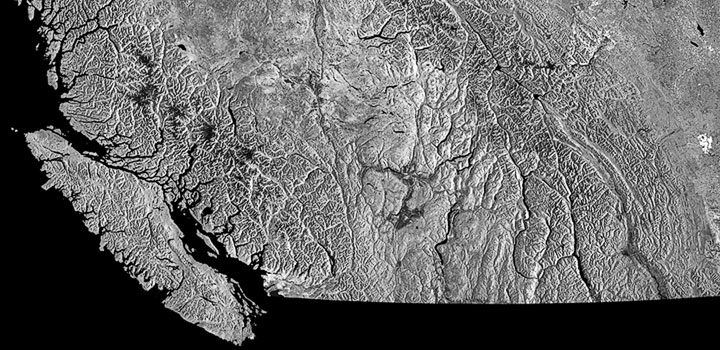 Radar map of southern BC mountains
Even on this scale, the mountains along the Coast (left) and the mountains through the Kootenays (right) are much rougher than those in the Okanagan (centre). At a higher resolution the differences are even more striking.
The radar image of the mountains through southern British Columbia shows that the roughest (most uneven) terrain is in the mountains along the Coast (left) and in the Kootenays (right), while the smoothest terrain is in the Okanagan (centre). This is despite the fact that on average, the elevation of all these mountains is much the same. On this basis, one would expect that the winds which flowed in from the Pacific and across the Province somewhat above the mountains would: be fast over the ocean, slow down over the coastal mountains, speed up somewhat over the central region and then slow down again over the Kootenays. The next question then is: why does this variation in wind speed produce ascending and descending air?
 Horizontal convergence
Air converges when it arrives faster than it leaves—the extra air ascends.
Convergence and divergence: Imagine a large box sitting in the atmosphere just above the irregular coastal mountains. The air enters it rapidly from the Pacific and is slowed by friction over the rough mountains and so leaves the box towards the Okanagan more slowly than it entered; the air has converged in the horizontal. And just as the water level in a bucket will rise if water is poured in more quickly than it can drain out, so the air in this box will ascend.
 Horizontal divergence
Air diverges when it leaves faster than it arrives—the extra air is supplied by descent.
Now, imagine a large box sitting in the atmosphere just above the much smoother Okanagan. The air enters it slowly from the coastal range and, owing to the smaller friction, is now accelerated by the pressure gradient force. As a result the air leaves the box faster than it entered; the air has diverged in the horizontal. And just as the water level in a bucket will fall if water is poured in more slowly than it drains out, so the air in this box will descend.
Horizontal convergence
Air converges when it arrives faster than it leaves—the extra air ascends.
Finally, we imagine a the box sitting in the atmosphere just above the irregular mountains of the Kootenays. As with the situation of the coastal mountains, now the air enters rapidly from the Okanagan, is slowed by friction over the Monashees, Selkirks, and Purcells and so leaves the box towards Alberta more slowly than it entered; the air has converged in the horizontal, and as before, must ascend.
Clouds and precipitation: Over the coastal mountains where the air is ascending, clouds and precipitation form to give the observed rainfall and snowfall. Over the Okanagan, where the air is descending, clouds are dissipated so that region receives less precipitation. Again over the Kootenays, the air ascends and leads to heavy precipitation. The general pattern is explained, and this explanation did not depend upon air that flowed up the sides of the mountains, but upon the convergence and ascent that resulted from the roughness of the mountains.
Coda: Of course, there is more involved in explaining everything that contributes to the annual precipitation—summer thunderstorms behave somewhat differently—yet, the basic behavior that produces the interior wet belt turns out to depend upon mountain roughness rather than mountain elevation (as is so often claimed). This explanation accounts for the behavior of the winter storms which bring snow to the Kootenays, a snowfall which rivals anything found at the Coast.
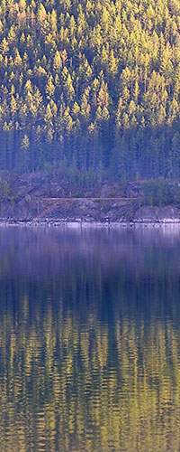
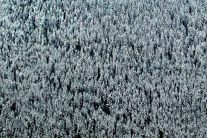 Fresh snow on the mountainside
Mountains, snow and trees surround Kootenay Lake. The heavy winter snowfall owes much to the roughness of the terrain.
![]()