Snow level, rime, and virga
Starting in November when snow has yet to cover the whole mountainside or reach the valley floor, Environment Canada tells people in the cordillera where they might encounter the snow level. Forecasters offer statements such as: snow level 1000 metres lowering to valley bottom near midnight. I appreciate these insights, but just what do they mean by the snow level? Is it the same thing as the (so called) freezing level—that is, the 0°C isotherm? No, it isn’t and therein lies a story of meteorological intrigue involving freezing, falling, melting, and evaporation.
If you were to believe your grade–school teacher, water freezes when its temperature drops below 0°C and ice melts when its temperature rises above 0°C. Fortunately, nature is vastly more subtle than this.
Certainly, water in bulk (puddles to lakes) will turn to ice when its temperature drops below 0°C, but water in minute quantities—cloud drops, even raindrops—normally will not freeze until the temperature decreases to maybe -20°C or even -30°C. And while ice warmed above 0°C will almost always melt, it remains that getting ice to those temperatures quickly is not simply a matter of surrounding it with warmer air.
Rime Most dictionaries do a good job of describing rime as ice that forms when (supercooled) cloud or fog drops freeze onto solid surfaces. One dictionary claimed rime was frost formed by the freezing of water vapour. That explanation is garbage: frost forms from the condensation of water vapour; rime forms from the freezing of supercooled water droplets—different processes, different appearances.
Rime on the mountainside
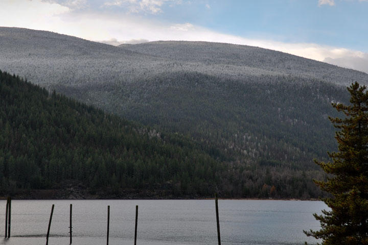
Clouds in air having a temperature between 0°C and maybe -20°C normally contain water drops, not ice crystals. The droplets are supercooled, to be sure, but liquid, nonetheless—indeed, that is what supercooled means: liquid at temperatures for which freezing is possible. When these drops make contact with some solid object they freeze instantly and the object becomes covered with rime. When stratus rests against a mountain, the portion of the cloud at an altitude above the 0°C isotherm will coat the trees with rime; the portion below, will not. The result is a sharp division: rime higher on the mountain than the 0°C isotherm, but none below. Although this pattern is often believed to result from snow, it does not; a snow fall does not leave a sharp transition.
Snow level A search (2010) of a glossary offered by Environment Canada revealed no definition for snow level. But, another document defines it parenthetically as the "lowest level with a nonzero falling snow rate." As the discussion and pictures herein show, this is a reasonable choice.
Snow level
Snow forms and grows in a cloud of water drops (see cirrus) at temperatures far below 0°C. The snow (ice crystals and aggregates of ice crystals) sometimes will fall into lower portions of the atmosphere where the temperature is greater than 0°C. But, this snow does not melt abruptly. A few things prevent it. First, the large particles of snow take a while to melt and so may fall well below the 0°C isotherm before melting into raindrops. Second, both evaporation and melting of snow cools the surrounding air with the result that unmelted snow crystals can descend in this cooled air even farther. Finally, the resulting pockets of cooler air are negatively buoyant and so the air descends and drags its burden of snow down with it. So, falling snow makes a gradual and uneven transition from ice to water and the snow resting on the mountainside reflects this: the transition from snow to clear is tapered, not sharp. The (rather indistinct) lower boundary is the snow level.
Virga Dictionaries present virga as streaks of rain hanging below a cloud because the rain evaporated before reaching the ground. This is not actually a definition; it is a (failed) explanation. The basic meaning of virga is streaks, in this case precipitation streaks. What these streaks are made of, and why they seem to hang above the ground constitutes an explanation. Dictionaries should avoid explanations, which all too often they get wrong.
Virga
Virga (Latin for rods or streaks) is the term used to describe streaks of precipitation which appear to hang below a cloud. Although sometimes explained as being rain which does not reach the ground because it has evaporated, the streaks are actually snow showers. And the transition to relative clearness below the streaks is not the result of evaporation, but the consequences of melting. The visibility of snow and the rain produced when it melts is very different. The snow shower is quite noticeable: it contains particles with a large cross sections and small fall velocities. The small fall velocities result in high crystal concentrations. The resulting rain shower below it is far less visible: it contains particles with small cross sections and large fall velocities. The large fall velocities result in low raindrop concentrations. The highly visible streaks of snow just seem to hang there because the rain below it is vastly less visible.
So, the lower edge of the virga is where Environment Canada places its snow level (the Department’s term is certainly a more intuitive one for the public). The altitude of the snow level is well below that of the 0°C isotherm. But, the 0°C isotherm does mark the sharp dividing line on a mountainside between rime and no rime.
Although the explanations behind these distinctions can be detailed, the features themselves are easily seen, especially in November when snow has yet to turn the whole mountainside white.
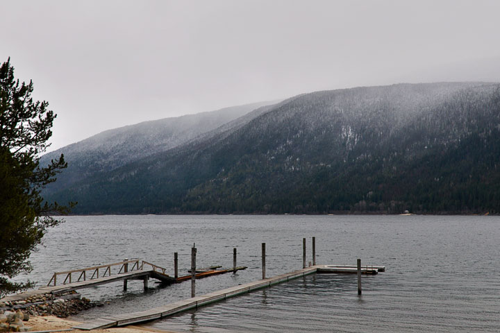
 Rime on the mountainside When stratus has rested against the mountainside, the portion of the cloud above the 0°C isotherm will contain supercooled cloud droplets which will freeze on contact with the trees and coat them with rime. Below that, the trees are merely wetted. When the cloud has vanished, the mountainside shows a sharp division: rime above, wet trees below. This picture does not show snow. Compare this with the similar view, below, showing snow.
 Rime on the mountains above Procter in mid November.
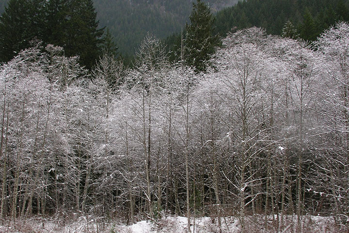 Rime coats the bare branches of broad–leaf trees alongside a creek. The temperature is low enough to give supercooled steam fog over the creek. The steam fog then drifts over the trees and coats them with rime.
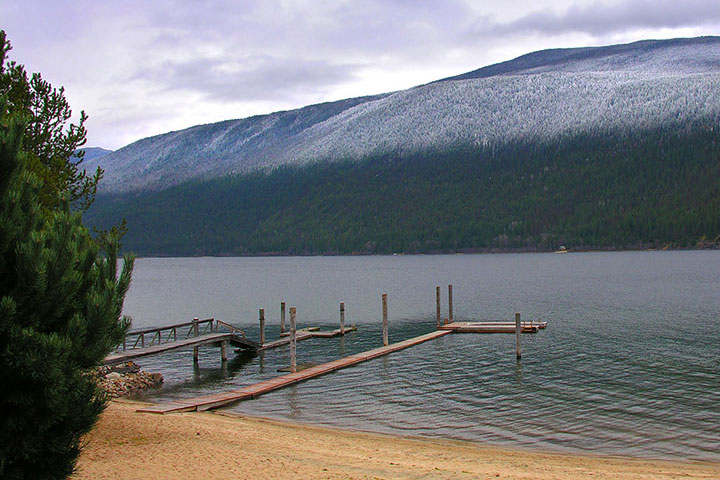
 Snow on the mountainside When snow falls onto a otherwise snow–free mountainside, it presents a gradual transition even when the 0°C isotherm is half–way up. Snow contains crystals of various sizes and they do not all melt at the same rate as they fall. This leaves a diffuse transition starting from all snow at the top to all rain at the bottom. Further evidence that this is snow, rather than rime, is found in the clearings where the snow has fallen between the trees to the ground. In a small clearing, rime would have been found dominantly on the tree tops.
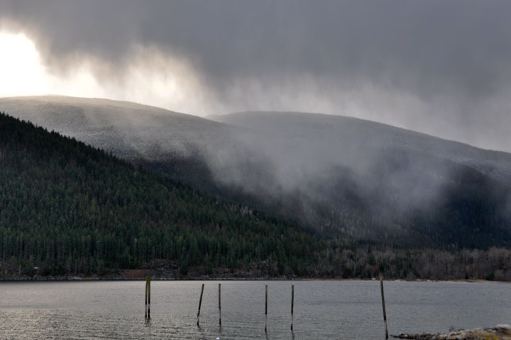 The differential falling and melting rate of the crystals within a snow shower is not the only reason the transition from snow to rain is diffuse on the mountainside. Both melting and evaporation cool the air making it negatively buoyant. This results in sinking pockets of colder air which spread some snow farther into the warmer air below.
 The mountainside in the left picture is seen after the shower. The boundary of the snow is gradual.
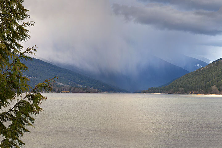 Virga hangs over the West Arm. The streaks are snow showers. As the snow melts it turns to rain, which, by comparison, is nearly invisible. It appears almost as if the precipitation has vanished—maybe even evaporated—but, it hasn’t. It is raining at the valley bottom below the virga.
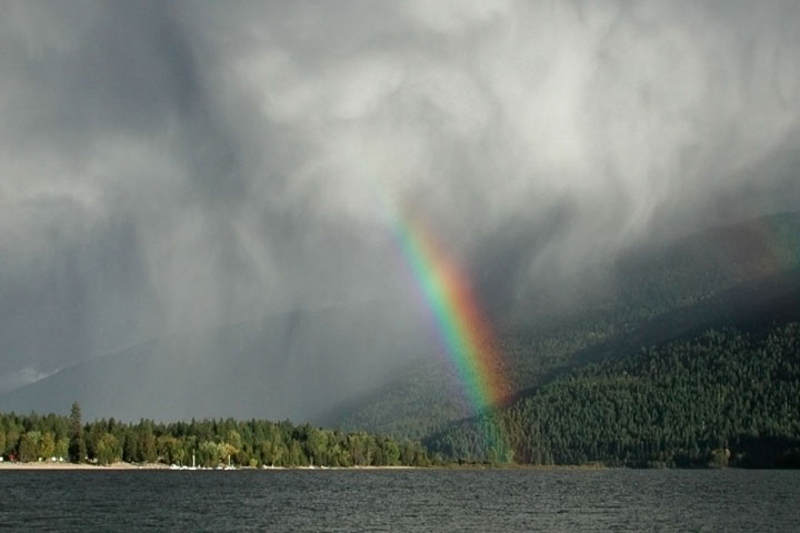 Virga hangs above a rainbow. Sometimes favourable lighting enables the rain to be seen. This is certainly the case when a rainbow appears below the snow shower.
![]()